What is it? How will They Build it? Can they Keep the Fish Out?
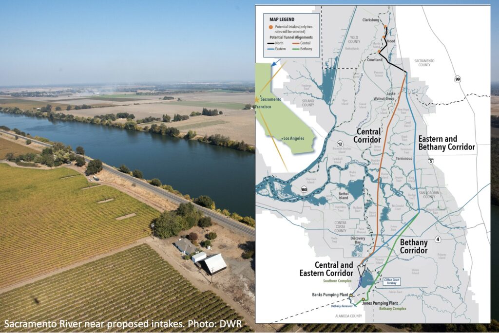
In late July, the California Department of Water Resources released an environmental impact report for construction of a 45-mile-long tunnel – or “conveyance” — that will divert high quality water from the Sacramento River, downstream of the state capital, and deliver it to pumps on the southern edge of the Delta for export. The following offers a short review of the basics behind this ambitious and complicated project. The review was produced by Estuary News Group for Maven’s Notebook, written by John Hart, Dianna Bautista, and Robin Meadows, and edited by Ariel Rubissow Okamoto.
Since Spanish days, Californians have been moving water from wet places to the dry places where we mostly choose to live and to farm. Today the largest and most contested water movement is the transfer of flows from the Sacramento River to the San Joaquin Valley and points south and west. In between lies the Sacramento-San Joaquin Delta, the state’s hydrological and ecological crossroads.
Beginning in 1953, water diverted from the Sacramento River near Locke has been making its way through various Delta channels to enormous pump intakes near Tracy for further export. In 1967, a battery of state-run pumps approximately doubled the sucking power of the earlier federal ones, with a further boost in 1986 when four additional pumps came on line.. On average, the two projects move more than four million acre-feet of water per year. This amounts to roughly one tenth of the water California farms and cities consume.
This system of “Delta conveyance,” threading the Delta labyrinth, is unsatisfactory in many ways. From an engineer’s point of view, it is inefficient. Water that might feed the pumps must be permitted to flow on west so that the channels near the intakes remain fresh. From a biologist’s point of view, the system is a disaster. It distorts and accelerates flows, hurries phytoplankton nutrients out of Delta waters, confuses ecologically important fish and leads them into predation traps, and fosters pollution buildup and harmful algae blooms. While it is hard to disentangle the effects of this particular configuration from the more general damage done by the sheer scale of water export (and reduced outflow toward the Bay), clearly the present system makes matters worse. Recently a new threat has commanded attention: sea level rise will bring saltier water with it, making the old facilities less and less usable over time. The salty end could come even sooner if a major earthquake were to crumble Delta levees.
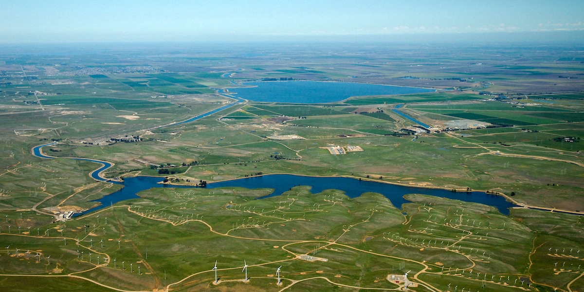
Ever since the first Tracy pumps began their work, the responsible agencies have been studying ways of getting water past the Delta without going through it. The proposed Peripheral Canal would have skirted the region to the east. Governor Jerry Brown’s twin tunnels were a sort of Canal gone underground. Now comes Gavin Newsom’s tunnel plan: a single bore, beginning with intakes at Hood on the Sacramento, sweeping southward parallel to Interstate 5, and bypassing the existing pumping plants. A whole new set of pumps would lift tunnel water directly into Bethany Reservoir on the California Aqueduct, out of reach of rising tides.
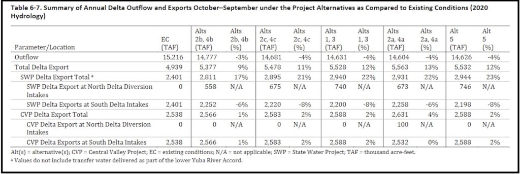
The new facility will be large enough to do nearly the whole job of transporting water south, replacing the defective through-Delta transfer method. In the first decades, however, the tunnel will not be used that way. Rather, it is to be a supplement, allowing more harvest of high Sacramento flows in wet periods. The projected result, according to the DEIR, is to restore Delta exports to levels not seen in recent years. State Water Project customers south of the Delta will receive almost one quarter more than they did in the 2020 water year that is the basis of comparison. The federal Central Valley Project, though not tied in to the new waterworks directly, is also expected to benefit to some degree. If a new project is not built, on the other hand, exports will continue their recent decline as persistent drought continues to reduce the amount of water available for all users.
The DEIR considers a long list of possible impacts on the environment. Many readers will go straight to the pages concerning salmon, delta smelt, and other fish species in decline. Plainly, the new intakes at Hood will do a far better job of screening out fish than the old intakes near Tracy do. Not highlighted is the fact that the antiquated facilities in the south Delta will continue to do most of the work for many years. Since the present bad situation is “existing conditions,” the cost to fish of continuing this “dual conveyance” is not analyzed in the DEIR. The net effect of the tunnel on fish species is judged to be “less than significant.”
The new tunnel is expected to carry up to 6,000 cubic feet per second of water. Located 100 feet below the ground, the tunnel will have an external diameter of 39 feet and an internal diameter of 36 feet. For scale, its diameter is about the length of a school bus.
Building a tunnel in the delta, as opposed to a surface canal, for example, is an attractive alternative for several reasons. As Graham Bradner, executive director of the state’s Delta Conveyance Design and Construction Authority explains, the tunnels are “more seismically resilient, particularly in a setting like the Delta, where you’ve got shallow foundation soils that are loose, poorly compacted, and pretty difficult to construct on.”
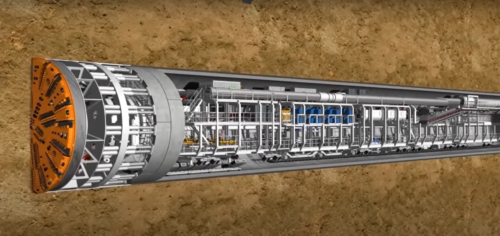 To build the tunnel, developers will use Tunnel Boring Machines (TBMs). The conveyance construction plan proposes to have four to six TBMs operating at the same time, each boring a different, 6-15-mile-long, segment of the total tunnel. Once they are all operating, the boring work itself could take 3-7 years for each section of tunnel.
TBMs work by digging into the soil using discs and picks inserted into a rotating cutter head that loosens and removes the excavated material. Engineers will custom design the cutter heads for Delta conditions and soil types. As the TBM bores its way through the ground, its work is carried out in three different compartments: the digging part up front, a middle part for moving of excavating material out of the way, and the rear trailing gear part featuring a conveyor belt that takes the material to the surface.
For the Delta project, a specialized kind of TBM called an Earth Balance Pressure TBM will likely be used (its name refers to how it works, by balancing the pushing ahead pressure on the cutter head with the pushback pressure from the earth at the interface). Engineers monitor and make real-time adjustments to manage the amount of pressure the TBM exerts at the head-earth interface.
While operating, the TBM uses water and foam to cool the interface and soften the excavated material so it can flow through the head of a rotating augmented screw that moves the material onto a conveyor belt that transports it to the surface for storage.
 While the TBM head bores, machines behind the head construct the tunnel lining in a sheathed area. The lining consists of six-foot-wide interconnected rings. Each of these individual rings are made up of eight precast concrete segments linked via tight gaskets to ensure that the tunnel is both watertight and seismically sound. Once a ring is completed, the TBM moves forward six feet and begins a new excavation cycle.
The TBM’s rear compartment contains power cables, a conveyor belt, and other trailing gear and machinery that supports the tunneling activity. A crew of 10-20 will work in this expansive, double football field-sized area.
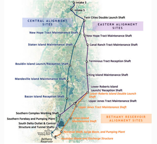
Above ground, the project will include: multiple launch sites where the TBMs begin boring and where the project can store excavated material and the precast cement segments; maintenance shafts where repair crews can access TBMs; and reception shafts where the TBM finishes its tunneling work. According to Bradner, it was particularly important to determine suitable locations for the launch sites due to their size, the need for road access, and instability of some Delta soil.
While millions of Californians depend on water from the Sacramento-San Joaquin Delta, so do about 50 kinds of fish, including sensitive species from smelt to salmon to sturgeon. Water for people is drawn from the south Delta via export pumps. The Delta Conveyance would tunnel water directly from the north Delta to the south, giving the state the option of capturing more water during the winter wet season when rivers run high. Fish protections include deploying the latest technology to screen them out as well as diverting water at the right place and times.
The proposed conveyance’s north diversion site is on the Sacramento River, shortly after it enters the Delta. This stretch promises to minimize harm to fish because it lies along a migratory route, so they’re generally just passing by. The site is also upstream of the saltier waters frequented by Delta and longfin smelt, which are listed as endangered and threatened, respectively.
The engineering and operation of the conveyance are designed to be as fish friendly as possible. The nitty-gritty of these fish protections is informed by comparable large-scale diversions for water suppliers and hydroelectric power plants. “It’s a known entity,” says Darryl Hayes, supervising engineer for the Delta Conveyance at the state Department of Water Resources, adding that diversion facilities of similar size are already in place in California, including elsewhere on the Sacramento River system, as well as other parts of the world.
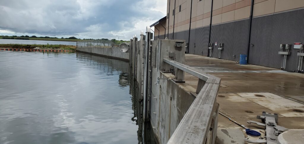
The conveyance team envisions a pair of quarter-mile-long intakes about two miles apart on the banks of the Sacramento River between Clarksburg and Courtland. To help keep fish from being swept up in the diverted water, the intakes will be fitted with protective screens. The stainless steel mesh is remarkably fine, with slots that are only wide enough to let a quarter slip through.
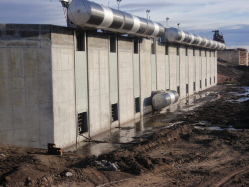
The team opted for cylindrical screens rather than flat ones. While the two configurations are equal in fish protection, the former have several advantages. Cylindrical screens are silent, clean themselves with motorized rotating brushes that dislodge mesh-clogging algae and shellfish, and allow for shorter intakes that give the facility a 30% smaller footprint along the river.
The proposed cylindrical screens are massive at 29 feet long, eight feet in diameter, and about 18,000 pounds, and as many as 30 would be installed at each of the two intakes. Bigger screens are better for fish. “A larger surface area per unit of water volume keeps velocity low,” explains Hayes. Slowing water as it enters an intake helps nearby fish resist that sideways suction and keep swimming along the river.
The intakes meet fish agency standards for delta smelt, which are the most stringent because they are the weakest swimmers in the Delta. The standards specify the speed of diverted water flowing through the screens (approach velocity) as well as the speed of water flowing past the screens (sweeping velocity). Approach velocity depends on the rate of water flowing from the river into the intake, and is set at 0.2 feet per second. Sweeping velocity depends on how fast the river is flowing past the screens. DWR has agreed to cease intake diversions when river velocities are at or below 0.4 feet per second.
Another operational fish protection is pumping at low levels when large numbers of young winter-run Chinook, which are endangered, migrate down the Sacramento River en route to the ocean. Pumping could also be adjusted in real time to reflect the behavior of young salmon. For example, when possible the pumps would run during the day time, when fewer fish are passing the screens. “They tend to migrate at night,” explains Gardner Jones, the conveyance team’s Endangered Species Act permit lead.
After the conveyance is built, the team could add fish refugia, structures intended to provide safe resting spots. Refugia are designed to let native fish in but exclude the nonnative fish that prey on them. “They’re like motels for fish,” Jones says. The idea is attractive but it’s unclear how well fish motels work in practice. Unknowns include whether fish use them, and whether they’re as safe as they sound. It’s possible that they’re actually attractive nuisances where predators congregate near the exits and pick off native fish as they come out.
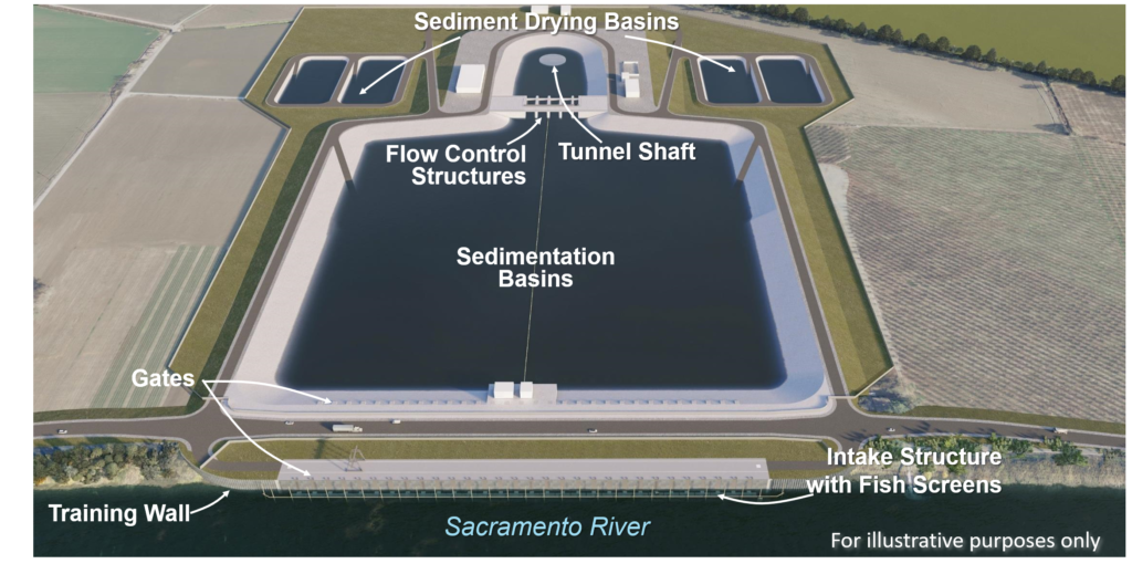
Fish screen technology has advanced enormously since the south Delta intake was installed at Clifton Court Forebay more than half a century ago. The current moves lazily there, which Hayes likens to the bathtub drain of the Delta, and water and fish alike drift into the pond-like forebay. In contrast to the fine mesh of the screen proposed for the north Delta intakes, the screen at the existing southern intake has vertical slits that are widely spaced at one inch apart. This creates turbulence that deters fish from the intake and funnels them to holding tanks. Fish are then trucked back to the Delta. “It was state-of-the-art in 1955,” Hayes says.
Although south Delta diversions would continue even after the new north Delta intakes are in place, there are no immediate plans to modernize the aging Clifton Court facility. Besides being sluggish, the water there is strongly tidal and so reverses direction, making engineering a challenge. Updating Clifton Court would also be tremendously expensive. That said, Jones points out that the aging facility increasingly needs costly repairs.
Over the last 25 years, a wide variety of fish screens have been built throughout North America and California, especially in the Central Valley — and screens like those for the proposed north Delta intakes work “very well,” says Jon Mann, a conservation engineer at the California Department of Fish and Wildlife. “We have seen an increasing improvement in fish screen technology, particularly with operations and maintenance,” he continues. The proposed design for the Delta Conveyance fish screens represent the state-of-the-art for fisheries protection.
The DEIR explores many areas in detail. Others do not fall within its limited scope.
How does the proposed project square with the state’s declared policy of reducing reliance on water derived from the Delta watershed?
As the table below shows, the preferred alternative (#5) would increase Delta exports, compared to the 2020 water year, while reducing outflow toward San Francisco Bay.
What is the lifetime of the project?
The DEIR says little about the period after 2040, when sea level rise is expected to speed up. How long can dual conveyance continue after that? When will the tunnel become the only means of sending water south?
What about the federal Central Valley Project?
Unlike prior conveyance proposals, the new plan does not feed water directly to the CVP. How will the feds cope with global warming challenges? It’s a question of concern, especially to large agricultural customers in the San Joaquin Valley.
Can continued dual conveyance be made less deadly for fish?
In a 2017 California WaterBlog analysis of north Delta conveyance scenarios then under consideration, UC Davis fish experts Peter Moyle and James Hobbs preferred the original two tunnel option (the now defunct WaterFix) over the single tunnel plan now proposed. Two tunnels could move more water from the north Delta, lessening the current disruption of natural flows. With one tunnel, the bulk of diversions will still come from the south. “From a smelt’s perspective, this is just a step above the status quo,” wrote Moyle and Hobbs.
What about possible effects on San Francisco Bay?
While informative in many areas, the DEIR does not look into any impacts of increased Delta exports (and thus decreased Delta outflows in some years) on the lower San Francisco Bay estuarine system. Are these effects really too small or uncertain to discuss?
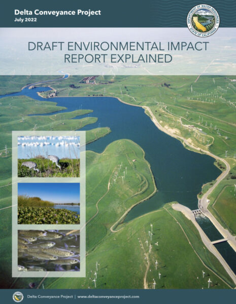 To help understand and navigate the Draft EIR, DWR has prepared several informational resources and tools. Items include videos, fact sheets, brochures, flyers and more. You can access those items here.
To access the draft environmental impact report, click here.
The draft environmental impact report is available for public comment until October 27, 2022. Click here for information on how to submit comments.
- What is the Draft EIR Fact Sheet (English and Spanish)
- Tips for Commenting on an EIR Fact Sheet (English and Spanish)
- Draft EIR Explained
- “A Guide to the Draft EIR” video series (5): Project Overview; Purpose and Objectives; EIR Contents; Resource Chapters; How to Comment
- “Resource Explainer” video series (6): Description of the Proposed Project and Alternatives; Tribal Cultural Resources; Terrestrial Biological Resources; Fish and Aquatic Resources; Water Quality; Air Quality and Greenhouse Gases
- Draft EIR Flyer (English/Spanish, Chinese, Hmong)
- Mailer (English/Spanish)
- Draft EIR Explained – Summary Booklet
About the Delta Conveyance Project
- DCP Overview and Update Fact Sheet
- Quick Questions Video Series
- Climate Realities Social Media Video
- Project Story Map
- Deep Dive Video Series
- Comparing the Delta Conveyance Project to Previous Conveyance Proposals Fact Sheet
- Preliminary Design and Engineering Objectives Fact Sheet
- Delta Conveyance: A Fresh Look Yields a New Project
- Big Storms, Dry Spells, Demonstrate the Need for Improved Infrastructure and the Delta Conveyance Project
Stakeholders (in alphabetical order)
Don’t miss John Hart’s meticulously researched new article – A Century of Delta Conveyance – now posted in the California Water Library.

