This issue explores possible futures for a Delta island, and features research from the latest issue of San Francisco Estuary and Watershed Science on topics including two kinds of monitoring bias. And don’t miss our links to some special features from Estuary Magazine!
Asked to suggest an appropriate future for four Delta islands owned by the Metropolitan Water District, it’s difficult not to want the moon. Why not rich rice fields, new wetlands, better boat launches, extended trails, more access? A new survey for the Delta Islands Adaptation Project, funded by a Prop 1 Watershed Restoration Grant, wants the public’s opinion on the importance of 10 possible land-use objectives leading to the selection of one of the four islands for improvements. As your blinking cursor hovers over a satellite image of Bouldin, Bacon, Webb, and Holland Tracts, the survey lays out all that the experts know already: Holland is the least subsided; Bouldin the most accessible by road; Webb the best candidate for making more fish food, and more. “The Central Delta has some of the most critical landscapes in the state, and also some of the most vulnerable to sea-level rise and flooding,” says UC Davis landscape architect Brett Milligan, who is facilitating the survey. As the Delta public ranks and rates various objectives, one respondent might want to preserve a beloved farm, another to re-ignite local indigenous stewardship, a third to reduce GHG emissions; opinions are sure to vary. “The planning vision is a mix of land-use strategies–both regenerative and experimental–spread across the one island,” says Milligan.
Author: Ariel Rubissow-Okamoto
Rain or shine, farmers in California use about the same amount of water every year, while residential water use varies considerably with precipitation. A research team led by UC San Diego’s John Helly processed 15 years’ worth of water-use data from the state’s Department of Water Resources, reporting in the March 2022 issue of San Francisco Estuary and Watershed Science that while “the annually precipitated water supply in the Bay-Delta” varied by 30%, agricultural water use scarcely changed year to year. “The water management system maintained nearly constant agricultural water use even in periods of intense drought, with year-to-year variation of about 7%,” the authors wrote. Residential water use showed more variability, swinging by 205 from one year to the next–mainly, the authors theorize, as the result of voluntary and mandated water conservation during droughts. Though Helly says he had no expectations of what his data analysis would find, he says “it makes sense” that agricultural swings in water use are less extreme than residential ebbs and flows. Long-term financial investments in water-intensive crops, he suggests, could motivate farmers to do everything in their power–like drilling deeper wells when necessary–to minimize annual variation in water flow. “Farms seem to use as much water as they can get, probably because they have a lot invested in their industry, whereas urban areas have more flexibility to conserve during droughts,” Helly says. He is now planning a follow-up study of how the water balance in California is affected by human behavior and land use.
Author: Alastair Bland | Photo: Amber Manfree
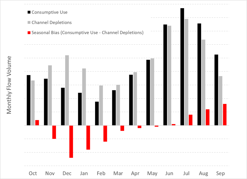
An examination of 50 years of records reveals an apparent seasonal bias in estimates of freshwater flow from the Delta to the San Francisco Estuary, with flow overestimated during the summer months and underestimated during the winter. Estimates of Delta outflow use a measurement called net Delta outflow index (NDOI), which is determined by taking the amount of Delta inflow, from sources such as the Calaveras, Sacramento, and San Joaquin rivers, and subtracting Delta exports, a direct measurement, and net Delta channel depletions. A team led by TetraTech’s Paul Hutton compared NDOI estimates against measured Delta outflow at four points, as well as against the Estuary’s historical salinity record. The study, which appears in the December 2021 issue of San Francisco Estuary and Watershed Science, focused on net Delta channel depletions, which are determined indirectly and involve considerations such as land and water use, crop evapotranspiration, and soil moisture. The seasonal bias was an (estimated) average of 1,000 cubic feet of water per second over or under the NDOI estimates, a significant percentage of typical summer outflow. Accurate accounts of freshwater flow to the Estuary, also called the Delta outflow, are important because they influence water management. “The Central Valley Project and State Water Project operations, for example, rely on real-time estimates of Delta outflow to guide regulatory compliance of reservoir releases and Delta exports,” explains Hutton. While the Delta Watermaster is currently collaborating to improve one area of net channel depletion estimations, better crop evapotranspiration assessments, ut Hutton believes more needs to be done, such as accurate assessments of the changes in local soil moisture and other aspects of net Delta channel depletion, to obtain more overall accurate NDOI estimates.
Author: Dianna Bautista | Above: Conceptual chart of seasonal bias. Image courtesy of Paul Hutton.
Scientist Sam Bashevkin spends his time making the millions of data points collected by Delta researchers–where the fish are, how fast the water is flowing, what’s the salinity on a certain day and time on a particular river bend–more accessible and useful to the other scientists and managers. In this 14-minute Science in Short interview with the Estuary News Group’s Ashleigh Papp, Bashevkin talks about the challenges and rewards of his work in data science for the Delta Stewardship Council, and how he’s applied his skills to complex data sets on everything from endangered fish to drought. “It’s really a form of storytelling,” he says.
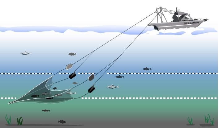
 Fish monitoring surveys in the San Francisco Estuary, which provide the foundation for so many critical management and conservation decisions, net different numbers of different fish species depending upon when and how they sample. And according to a new study published in San Francisco Estuary and Watershed Science, even surveys that target the same part of the water column can come up with significantly different catches. The study’s authors analyzed decades worth of data from the California Department of Fish and Wildlife (CDFW) Fall Midwater Trawl, which spans from San Pablo Bay to the upper Delta; CDFW’s San Francisco Bay Study midwater and otter trawls, covering the South Bay to the central Delta; and the UC Davis Suisun Marsh Fish Study, also an otter trawl. The two midwater trawls, which sample the middle of the water column, were found to be generally more successful at catching pelagic (open-water) fish like Delta smelt and American shad than the two otter trawls, which sample the bottom of the water column. The latter were more effective at catching demersal (bottom-dwelling) species like prickly sculpin and Sacramento sucker. The research also turned up unexpected distinctions between the two types of trawls that may have more to do with how and where equipment is deployed than the depth at which they operate, says lead author Brock Huntsman of the U.S. Geological Survey. “There was a decent amount of variability to which species were captured more efficiently with one gear type or one survey than the other, even when they were technically sampling the same habitat.” The new findings will help researchers studying fish populations Estuary-wide to more accurately combine and compare data from four key long-term surveys, Huntsman says.
Author: Nate Seltenrich
Atmospheric rivers—a meteorological phenomenon virtually unknown a few decades ago—now deliver about half of the West’s precipitation. In addition to replenishing reservoirs and the mountain snowpacks that store much of the region’s water, they also cause most of the flooding in the West, with economic damages reaching $1 billion a year. New research shows how much bigger and wetter these storms will become as the world warms, heightening the risks of catastrophic flooding and landslides, as well as of levee breaches in the Sacramento-San Joaquin River Delta that could threaten the state’s water supply. Knowing when, where and how hard atmospheric rivers will hit is vital to ensuring water supplies and avoiding floods. The Atmospheric River Reconnaissance program uses airplanes to meet the storms as they zoom across the Pacific Ocean and delivers real-time data to National Weather Service forecasters. For more on new research on ARs–including how they contributed to the 2017 Oroville Dam crisis–and the efforts to predict the paths and impacts of these storms, click here.
Above: Weather balloon being readied to track an atmospheric river.


