From Daniel Swain at the California Weather Blog:
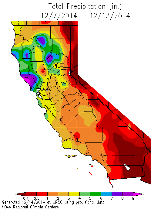
A very impressive winter storm brought widespread heavy rainfall to most of California last week.
A strong and moist atmospheric river–with a corridor of enhanced moisture transport extending all the way southwest to the Hawaiian Islands–occurred in conjunction with a rapidly-deepening surface low pressure area off the far NorCal coast, bringing a prolonged period of precipitation to much of the state (and the Bay Area/Central Sacramento Valley, in particular). Near the coast, the initial band of rain was extremely intense, leading to rainfall rates well over 1 inch per hour in some spots and causing widespread urban/flash flooding in the Bay Area. These very heavy rain rates–a product of shallow atmospheric instability and exceptionally warm ocean temperatures–persisted as the front slowly moved southeastward, bringing localized flash flooding and landslides to coastal areas as far south as Los Angeles County.
A strong wave developed along the cold front as it passed just south of the Bay Area, which allowed a large area of moderate to heavy rain to stall out over the Bay Area. As a result, 24-hour rain totals in the southern half of the Bay Area were exceptionally high, and in a few instances approached all-time daily rainfall records. San Jose, for example, saw its third wettest day in history (and its all-time wettest December day), and San Francisco saw its 11th wettest day in history (and its wettest since 1995). While modest regional flooding did result, rain rates were (fortunately) low enough (and watersheds dry enough) to prevent major flash flooding from occurring in most instances. …
Click here to continue reading at the California Weather Blog.
 Get the Notebook blog by email and never miss a post!
Sign up for daily emails and get all the Notebook’s aggregated and original water news content delivered to your email box by 9AM. Breaking news alerts, too. Sign me up!


