From Cannon Michael (@agleader), this guest commentary and rebuttal to yesterday’s Pacific Institute and NRDC Media Call:
California is experiencing a drought. It isn’t the first and it won’t be the last. This year only briefly started on par with the last big drought of 1977. Storms in February and March have pulled California out of that driest trajectory – see chart – and more storms are on the horizon.
Key reservoirs, such as Shasta, Folsom and Oroville in the northern Sierras are low as well as the San Luis Reservoir south of the Delta. These are key components of the Central Valley Project and the State Water Project. Zero allocations have been made for the Federal, State and Friant Contractors – 4,000,000 acres of productive farmland has been allocated no surface water for 2014. Looking back at the 1977 drought year, the Federal westside and Friant farmers all had 25% allocations, the State contractors had 40%. So why are things so different now? Why with the improving hydrology are we still seeing no improvements in allocation?
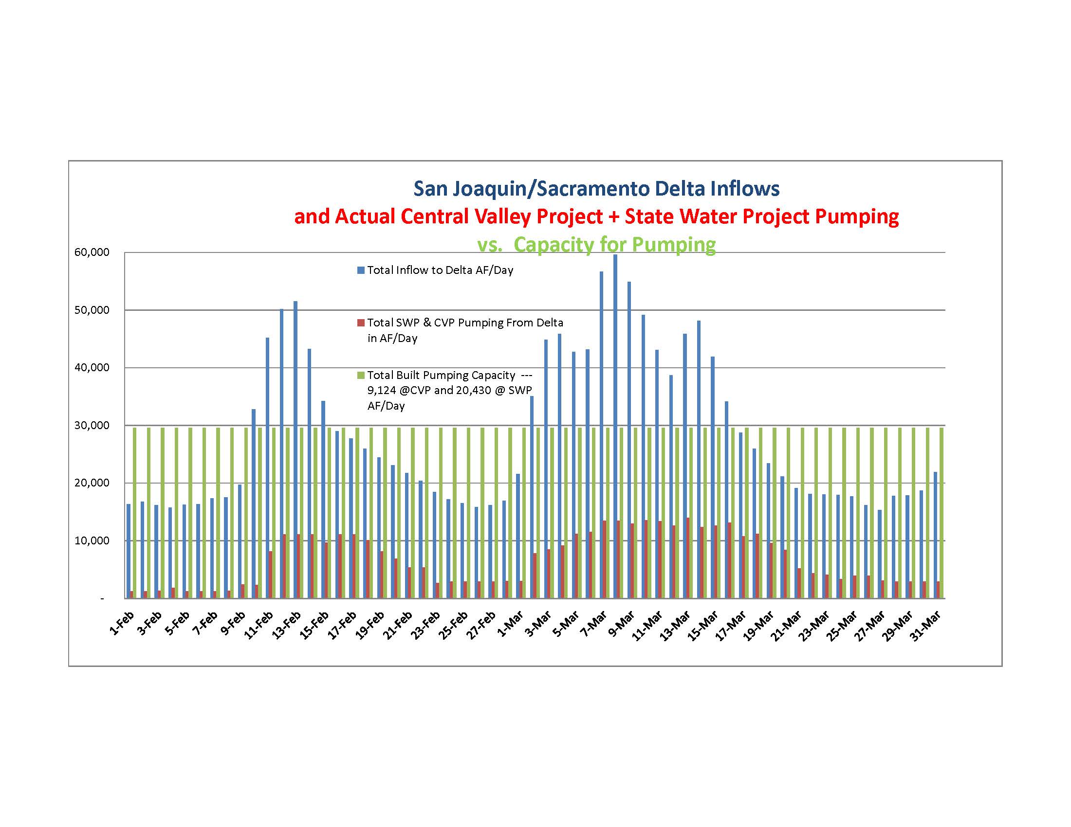
While some claim that regulation has nothing to do with the current situation, it is pretty easy to see that regulations are seriously limiting the amount of water we are able to export and store. Let’s take a look at a chart that clearly shows the impact of these regulations. For transparency sake the numbers on the chart can be found here: http://www.usbr.gov/mp/cvo/pmdoc.html. We can see from the blue bars where the Outflow in the Delta spiked up during the February and March rain events. The red bars represent the total pumping by the State and Federal pumps at Tracy in acre-feet. The green bars represent the total capacity of the pumps if all the pumps were allowed to run.
So it isn’t hard to see that the difference between the total Delta outflow and the amount of water allowed to be exported is very large. Over the past two months, much less water has been exported than what potentially could have been. At a time when farms, communities and wildlife refuges are desperate for water, why haven’t we been able to utilize the water system and infrastructure we have in place?
The bottom line is that federal ESA restrictions on the pumps have limited exports to the levels you see in the chart. These restrictions are designed to protect fish, but it is interesting to note that the fish haven’t been present around the pumping plants. The number of fish taken at the pumps during the past two months has been extremely low.
So it isn’t that fish are being ground up in the pumps, the pumps are restricted because of flow outflow requirements, ESA Biops (OMR) and the ratio of water that can be exported versus inflow to provide salinity control in the Delta. Under the current SWRCB Temporary Emergency Order the outflow standard was reduced to 7,100 cfs.
All water users agree that salinity control in the Delta is critically important. If the Delta salinity rises it isn’t good for fish or farmers – some common ground. What isn’t clear is the effectiveness of the ESA driven “reverse flow” restrictions which limit the flow of water towards the pumping plants. The standards were temporarily relaxed and no impact on fish was observed.
Recently a bipartisan group petitioned Secretary of Interior Jewell seeking a temporary relaxation of the regulations that are limiting exports – only to try and capture a portion of the current storm flows – after so much of the previous storm flows were lost to the ocean. No final decision has been made yet, but the request has raised the ire of a select few environmental and fish protection groups. They claim that temporarily relaxing restrictions and increasing exports “could” potentially harm fish – even though those asking for the relaxation have agreed to scale back if fish take increases.
So the “potential” jeopardy to fish is able to outweigh the “actual” jeopardy to millions of acres of farmland, communities, refuges, underground aquifers, and food supplies. The truth is that the water situation for many could be much better in 2014 if a common sense approach was used. Capture the precious water that is flowing out to the ocean and preserve it for uses that we can quantify.
There has been mention of the San Joaquin River Restoration Program and how flows were shut off this year to preserve water for human use. The truth is that almost 180,000 acre feet of water was released from March of 2013 (during the drought) to the time when flows were shut off in February of 2014. The month early shut off preserved less than 15,000 acre feet of water for use. While the San Joaquin River Settlement called for 10 key projects to be finished by December 12, 2013, not one of them has been started. The 180,000 acre feet released last year could have made a huge difference to the water outlook for many farmers and communities on the east side of the valley. Instead it went into a river that is no different than it was in 2006.
The bottom line and the truth is that during this time of drought precious and significant amounts of water have been allocated to perceived fish needs instead of actual human needs. Blaming the drought as the only cause of the current situation is a dishonest characterization of California’s water supply and the impact of environmental regulations on our ability to manage our water resources.
Written by Cannon Michael exclusively for Maven’s Notebook. You can follow him on twitter at @agleader.


