From USGS:
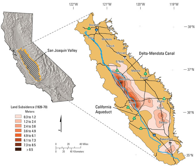
“Extensive groundwater pumping from San Joaquin Valley aquifers is increasing the rate of land subsidence, or sinking. This large-scale and rapid subsidence has the potential to cause serious damage to the water delivery infrastructure that brings water from the north of the valley to the south where it helps feed thirsty cropland and cities. According to a new report by the U.S. Geological Survey the subsidence is occurring in such a way that there may be significant operational and structural challenges that need to be overcome to ensure reliable water delivery.
The report concentrates on subsidence in an original study area along the economically vital Delta-Mendota Canal in the northern San Joaquin Valley, but also includes data from a subsequently discovered and much larger subsidence area that touches the canal on the southwest.
This subsidence is reducing the capacity of the Delta-Mendota Canal, the California Aqueduct, and other canals that transport floodwater and deliver water to agriculture, cities, industry and wildlife refuges. To help public agencies and resource managers minimize risk and damage to California’s infrastructure, the USGS is studying and providing information on groundwater conditions and land subsidence in the San Joaquin Valley.
“The USGS report was commissioned by the U.S. Bureau of Reclamation to learn more about the challenges we face due to subsidence. It will help us take additional proactive measures to ensure efficient delivery of water to the San Joaquin Valley,” said David Murillo, Mid-Pacific regional director of the Bureau of Reclamation. “The 2012 completion of the Intertie project, which connects the Delta-Mendota Canal and the California Aqueduct in the valley, was a major step toward addressing conveyance conditions in the federal water system,” Murillo said. … “
Continue reading at the USGS here: Renewed Land Subsidence Poses Risk to Water Infrastructure in California’s San Joaquin Valley


